Geospatial Fusion™ Solution: Unlocking Information, Providing Insights & Delivering Business Impact
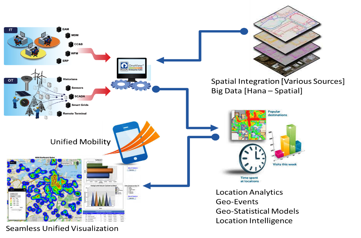
Rolta’s Geospatial Fusion™ Solution fuses information, applications and processes of an enterprise into a seamless architecture to produce world class business value.
Today, organizations are confronted with many challenges including disparate business systems, high costs, shortage of technical resources, budget pressures, and longer product development life cycles which often delay ROI. Rolta’s Geospatial Fusion™ Solution provides a framework to integrate disparate systems using seamless configuration techniques, cutting down costs and development time. The versatility of Rolta’s Geospatial Fusion™ Solution’s Framework allows partners to extend the capabilities of their solutions to create cost effective integration and improve time to market.
At the heart of Rolta’s Geospatial Fusion™ Solution is Rolta OnPoint™, which extends the value of legacy systems and GIS investments by enabling cross functional integration and creating additional business and operational intelligence. It helps create business value by unlocking hidden information and making it available in a context appropriate for any level of decision-making. The fusion of maps and business data empowers executives to obtain timely and accurate operational facts required to achieve business objectives.
Benefits:
- Rapid deployment and configurable features presentation reduces in IT project cost
- Configurable web map services reduces the efforts and cost of enterprise integration
- Industry standard security compliance
- Low cost of ownership
- Enables organizations to achieve operational excellence
- Aids risk reduction
- Helps increase stakeholder value
- Enables Enterprise Mobility automating field workforce management in connected & disconnected mode
- Easy interoperability with other BI systems seeking geospatial content and decision support systems
Value Proposition:
- Leverage sharing of enterprise resources with spatial context
- Empowers enterprise towards effective information sharing through spatially enabled workflow
- Achieve greater geo-processing and analytics capabilities to diverse natural resources assets
- Superior asset lifecycle management and workflow management
- Monitor spatial relevant KPIs impacting business using industry standard BI
- Geospatial enabled e-Governance ERP / Applications for various government services and workflows
- Spatial context to law enforcement enterprise data for planning, mapping and analysis.
- Provides deeper spatial integration for advanced Crime Analytics and Safe City
- Achieve smarter city initiatives involving real time geospatial enabled analytics for effective public services such as emergency response, critical protection, traffic control and emission control solutions

 Alabama Power Company, for many years, has had forward-thinking executive leadership that supports the advancement of technology for operating our distribution system and improving customer satisfaction…